Showing posts with label boynton road farm. Show all posts

Wednesday, October 30, 2019

The Kay's Cross Mystery finally solved for good? New eyewitness testimony, withheld for decades, tells all . . .

 Kingston United Order plus a Messianic California cult leader plus Lake Bonneville stone & coal mine rails = Kays Cross? Read on to find out the full, real story . . .

With Halloween just around the corner, it's time to think about the mystery of Kay's Cross again.

And do we have a whopper of a development today!


Late last night, relatives of Malvern Hansen wrote to share with me with a detailed account of the building of Kay's Cross:
I understand there's a lot of speculation surrounding an icon in Kaysville, the now infamous Kay's Cross.

With Halloween just around the corner, I have received permission to share the story of how it came to be, from one of the last survivors who helped to build it, my father, Malvern Hansen.

Following is his story, in his own words, that he's only shared with family prior to now. He journaled it in 2012.

It is his desire now, that whoever is interested have these details as there's been so much misinformation over the years.
Charles Elden Kingston in 1940

I hope you enjoy his recollection and that it can put a lot of questions to rest.
From Malvern Hansen's 2012 journal: 
In the summer of 1946 a man came to the people of the Co-op with a plan he wanted to present to us. He called himself Dr. Pencovic, but wanted to be referred to as Krishna Venta, which when translated to our language meant Christ returned. He was organizing a group in California and was forming this group into a form of united order. He was trying to get more people to join his group and wanted our people to join him.

The leader of the co-op was Charles Elden Kingston who wanted to be known and referred to as brother Elden and wanted to portray himself as being on an equal with all the members and our group was to be referred to as the Order. At the same time he was clearly the leader of our group.

I went to brother Elden with my concerns because I didn't believe Mr. Pencovic was Christ, and he informed me he was of the same belief. However he welcomed Pencovic in order to give all the members the chance to follow him if they chose.

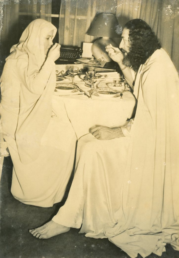
This man was about 6 feet tall, very good looking, wore a long robe, went barefoot and had a full beard.
Krishna Venta in 1946

After attending a few of our meetings he informed us that he wanted us to build a stone cross at the farm in Kaysville to pay tribute to the crucifixion and resurrection of Christ. Brother Elden agreed and organized a crew to do this. The men chosen to do this were Allen (Mac) Frandsen, Alfred Grundvig, Ammon and Ivan Nielsen, Ernie Ekstrom, Merlin Kingston, Malvern Hansen, Gerald Hansen. There may have been others, I am not sure.

A place was chosen on the hillside and we began working there. It started by us digging an excavation about a foot deep, about 10 feet long and about 6 feet wide. Then we took 3 pieces of steel rails that had been used in the coal mine to form the support for the cross. 2 of these rails were about 10 feet long and the third one about 6 feet long.

Krishna Venta in 1949
The 2 long rails were wired together at about 3 feet from the top end, then the cross rail wired to them. Then this structure was driven into the ground at the center of the excavation, then it was supported in the upright position and concrete filled the excavation holding it all in place.

Merlin, Gerald and myself had the job of gathering the rocks to make the structure. We got these rocks along the upper road where cherry hills subdivision now is. We chose rocks of suitable size and shape to do a good job.

This cross was about 9 feet tall and at the cross arm about 7 feet wide. The center of the cross about 6 feet high. At the base it was about 4 feet square and at the ends of the arms it was about 3 feet square sloping to about 2 feet where they all came together.
This view of Kay's Cross after it was destroyed
in 1992 shows the rails and other
construction details mentioned by Hansen
On the south face, right in the center was a recession about 3 inches deep and 20 inches high and 14 inches wide. Formed into this recession was the letter K which represented the word Knowledge.

After the foundation had hardened, Mac and Alfred laid up the rocks. I had the job of mixing the mortar which held the rocks together. Rather than regular mortar this was made of concrete without rocks in the mixture which made a very strong structure. Ernie created the form which formed the letter K.

The cross was never completed as we stopped work on it when Pencovic returned to California.
Krishna Venta and his wife, known as "Mother Ruth," London, 1949
 

Now a brief review about Pencovic. He was born and named Francis Herman Pencovic March 29, 1911, [and] had his name legally changed to Krishna Venta in a California court in 1951.

He openly stated he was Jesus Christ. He also claimed to have come to earth with a convoy of rocket ships from the planet Neophrates which had been destroyed for the wickedness of it's people. Soon after he left here he formed a religious cult named W.K.F.L. [Wisdom Faith Knowledge Love] at Chatsworth California.

He died in a suicide bombing carried out by 2 of his followers who blew up themselves and 8 other people after he had been intimate with the wives of these men.
This view of Kay's Cross shows the letter K and the T shapes mentioned by Mr. Hansen.  The ends of the cross arms seem to have a square shaped depression, but no recognizable letters (see first photo, above).
Other witnesses have explained that the T and square shaped depressions were intended to be filled with ornaments--work never completed (more on this later).
One of the rails mentioned by Hansen is clearly visible.
A followup conversation with Malvern Hansen in 2016 revealed a few more details:
The cross had a large letter K embedded at the center of the cross arms. There was a lot of speculation regarding what it represented, some thought it referred to Kingston, others thought it was Kingdom, but I remembered it as Knowledge.

At the end of each cross member was also engraved letters which I could not remember. This email helped me remember the other letters as W for wisdom, F for faith, and L for love, the symbol of his organization in California which he tried to organize here in Utah.
This photo of a portion of Kays Cross, 2010, shows many of the details mentioned by Hansen.
Photo credit: Rslnerd, Wikipedia, public domain

The cross was never completed, as he left before the completion and went back to California at which time we did no more work on it. Also my research found that his death by being bombed was mainly because he had been sexually involved with the wives of his killers.

I might be the only man alive who helped build the cross. If there is anyone else it would be Melvin Frandsen.

The cross was built because of Mr. Pencovic. It was part of his plan to get the Kingston group to be his followers.
The family member concludes:
My Dad is 96 years old and just wants to get the truth out there.

Does this solve the mystery of Kay's Cross?

Malvern Hansen's account is a detailed and, apparently, first-hand account of the construction of Kay's Cross.

And what a wild story it is--an isolated hollow, a secretive Mormon polygamist group and its leader, and a nascent messiah--who was later blown up by his own followers.

Is this really the story?
Think of all the stories that have been invented and passed down over the year to explain Kay's Cross: Crazed pioneer polygamists, wives buried in the cross-arms, satan worship, satanic cults, evil mysterious ghost-farmer with rock-salt in his shotgun guarding the place day and night/summer and winter, dog-men haunting the spot, murdered polygamous wives, murdered polygamous families,  William Kay and his wives, pioneers at all, polygamous family-murderers hanging themselves from the cross, six wives buried in a circle surrounding and one upright in the cross, a wife's heart buried in the cross-piece, a ghost-of-a-polygamous-wife-buried-under-the-cross-and-haunting-the-neighborhood, marauders, demons--all those and more have been passed in along in articles like this and this and this and this.

But if you grew up in Kaysville, you didn't need to read those legends on some web  page.  You probably heard them shared by your friends at school or your neighbors at church.  Or maybe told and retold during midnight hike to visit Kay's Cross.

Of course, none of us probably really believed the wilder legends, or maybe any of them. 

But Kay's Cross is such an unusual and striking artifact in such an unusual and unexpected place. 

What could explain it realistically?

What is the evidence?

Hansen's story certain makes sense on the face of it. We have already established that the Kingston group owned the Boynton farm starting in the 1940s. So the dates match.

Interestingly, although much of the speculation about the origins Kay's Cross I heard growing up in Utah involved some form of crazed or murderous polygamists, it is important to note that the Kingston group or any form of modern-day polygamist groups never figured into the picture.  Kay's Cross origins were always imagined back much further, well in the 1800s.  So murders or burials or other fantastic elements associated with the cross were always imagined to some how related to early Kaysville founders--never anything as modern as 1946.

So--just imagining Kay's Cross being built in 1946 rather than, say, 1856 or 1896 puts a whole new light on it.  And that brings up:

New evidence, new mysteries . . . 

Because Hansen's story raises as many mysteries as it solves!
  • Did Krishna Venta really meet and inspire the Kingston Clan leaders and followers in the 1940s? Is there any proof of this?
  • Are there any other available accounts of the building of Kay's Cross from this period?
  • Is there any other confirming or contradictory evidence to this version of the Kay's Cross story?
Stay tuned . . . 

Wednesday, November 30, 2016

Edward Phillips and the founding of Kaysville

The founding myth of Kaysville goes something like this: John Green and Edward Phillips were traveling north to Weber County when they were waylaid by snow, spending the night with Samuel Holmes. Holmes talked the two into settling nearby--and the three became the first Mormon settlers in the Kaysville area.
Edward and Hannah
Simmons Phillips

Here is the story, and a lot more about the early history of Mormon settlers in Kaysville, as told by one of the key participants, Edward Phillips:
In the winter of 1849-50 John H. Green and myself started north to hunt a farm. We traveled to the north extremity of the county (what is now Davis County) to the sandridge until we encountered snow so deep and frozen so hard that we could not travel farther. We concluded to return (rather than perish) to find shelter. We had intended going as far as Ogden finding us a farm, but the snow prevented us from doing so. We went back and stayed over night with S. O. Holmes.
The "sandridge" is the high sandy ridge located just south of the Weber River, approximately where Hill Air Force Base is now located.
We concluded the creek was the best place we had seen and returned in the spring of 1850. On or about April 10, 1850, I started with my family for what is now Kaysville Creek, but which many at present call Kay's Creek, but I arrived one day previous to Bishop Kay.
Fremont's Map of 1849-50 shows the Phillips, Holmes, and Haight farms.The survey has a number of interesting problems and errors, including the location of the main road and the creeks. Creeks are more or less correct as they leave the mountain canyons, and also as they intersect the three farms shown. But the wrong canyon is connected the wrong farm in a fairly comically incorrect way. More on that later.
Click for full sized version. Full, zoomable map online here. Source.
We settled there on Sandy Creek in Frosoloscey's survey which we called Phillips Creek. In a day or two after our arrival on what is now Kay's Creek, we took our plows and started about the same time. We had five bushels of club head wheat each, which we sowed broadcast. I sowed mine on six acres. Brother Kay sowed his on five. We plowed land for farming side by side, being about equal in quality. I raised two hundred fifty bushels from my six. He raised two hundred ten from his five.
I believe that "Frosoloscey's Survey" is a reference to the 1855 survey of Joseph Troskolawski, the first federal land survey of the area. If so, he is simply referring to the survey as a way to identify the area and the creek, not saying that they initially located the area or named the creek based on this survey--which happened some years after Phillips settled in the area:

1855 Survey of the Kaysville-Layton area by Joseph Troskolawski.
This is part of the first federal survey made in Utah. Note early roads and streams, including a road from Phillips farm to the immigrant camp area near the main road, and another from Kay's Fort to the Bluff Road.

Phillips, Holmes, and Haight were all located along the Bluff Road whereas Kay's Fort and the immigrant camp are located on the main road--later Utah Territorial Highway 1 and today Main Street/Hwy 273.

"Kay's Fort" is located near downtown Kaysville today. However, the fort was actually oriented strictly on the points of the compass, not skewed at a 45 degree angle as shown here.

I'll have more to say about this interesting survey and map later. Click for full-sized version
President Young paid us a visit after we had harvested our crop and he wanted to know how much I had raised. I told him two hundred and fifty bushel. I[He?] was asked why his[my?] crop was the best on the creek that season and I said it was due to the prayers I offered at the time of planting. He told of this in a sermon on the stand in the Salt Lake City Tabernacle, to try and show the increase.

This was done without a fence, but we had to stand guard night and day to watch as well as pray; for there were from one to two hundred cattle turned out every night about a mile above us belonging to emigrants who were on their way to the California gold diggings.
The land generally to the north and to the east of the Holmes, Phillips, and Haight farms had been used as open range by Mormon settlers from 1847 onwards, and now, apparently from 1849 onwards by California immigrants who were traveling through the area.


The location "about a mile above us" is almost certainly the point where the main road crossed Kay's Creek. Today this area is near the intersection of Main Street and Gentile in Layton and very near the Layton Frontrunner Station. This was likely an inviting spot to camp, with water and feed for the livestock both available near the road.

Near the location of immigrant camp area, today.Kay's Creek runs through the line of trees at the back of the field.
(Google Streetview)

If this area was used as a camping and grazing area for immigrant wagon trains, it would have been about 1 mile northeast of Phillips farm ("above"--i.e., directly upstream from Phillips) and 1.5 miles west of the Boynton Farm (see locations marked on the 1855 land survey, above). Livestock would easily have strayed 1-2 miles overnight, and so this documents one of the first known uses of the Boynton Farm area in the Mormon settlement era--as open range for livestock.

It also presents one of the first opportunities for the discovery of Kay's Cross by Mormon settlers or by California immigrants. If the Cross existed at this time--and that's a big if--it most certainly would have been discovered by one of the settlers or livestock drovers.
If this had been discovered in a hidden Holmes Creek glen in 1850, would the
discovery had gone un-announced? It seems unlikely . . .
And if it had been discovered, it most certainly would have been widely discussed and written about. A large Christian cross in a secluded hollow, apparently built by native Americans? That would have been a topic of discussion far too juicy to pass by . . .
The country north of us for almost twenty miles was covered with a luxuriant growth of grass. We called it bunch grass. In the fall of the year, it would wave in the breeze like a grain field. It was rich for wintering stock. That is now a dry farming country, raising from 15 to 25 bushels of wheat per acre. . . .
The area north of--and higher than--Kay's Creek had no available water in the early days. It took many decades and development of extensive canals before irrigation water was available in this area. Before irrigation was available, the land was only useful to them as open range for livestock. So dry farming the area was an important innovation by area settlers--and one they took with them to other places, for example, the Mormon settlements in Albert.

In 1850 I carried a chain for Surveyor Lemon form [from] the first creek south to our settlement, the first survey in this ward. After this, Jesse Fox was our surveyor.
I am not certain who "Surveyor Lemon" is, or if that 1850 survey is available.
The summer of 1850, I built a log house being the year the Ward was organized. The following summer, I built another and in 1853, I built the first adobe house in Kaysville Ward, consisting of three rooms. . . .
Edward Phillips home at 358 W. Center, Kaysville.
Figures near the center may be Edward and Hannah. Note stone construction--similar to Kay's Cross, and quite common in construction by Mormon settlers throughout the Kaysville area, after the "log cabin" era.
Utah Historical Society
In 1855, President Young counciled us to build a meeting house about two miles east of where we had settled. We selected a spot at which place there was a military post, the commander being Captain Joseph Taylor. We united with him for protection against Indians and walled in a fort about covering sixty acres. Some of the walls of which are still standing today. In this fort we had the foundation of the meeting house. The dimensions being 90 by 45 feet which is in a good state of preservation today. It was commenced in the winter of 1855 and 1856 and completed in 1862. About this time we were advised by the President of the Church to enlarge our fort sufficiently to make a city of it. After doing this, we built a wall around the whole of it consisting of one hundred twenty acres or a quarter of a section.
Our location was a beautiful one being between the Wasatch Mountains and Great Salt Lake. About six miles of rolling country between and from ten to fifteen miles from North to South. . . .
Location of Phillips Farm, 2016, view to the east
Kay's Creek is in the row of trees to the right; today's Angel Street approximates historic Bluff Road
(Google Streetview)


My farm where I first settled consists of one hundred acres divided into twelve fields with the intention of carrying the sheep industry. I have three artesian well[s]. One averaging three gallons a minute, one seven, and the largest 70-75 gallons per minute. This one supplies a fish pond which is well supplied with carp. I have lived to be nearly eighty years, to see the third generation. I have had eighteen children of whom thirteen lived to marry; ninety-nine grandchildren and some great grandchildren.
Connection to Kay's Cross and the Boynton Farm:  Phillips was one of the first settlers in the Kaysville area. He lived about 3 miles west of the Boynton Farm. He is among the first Mormon settlers to run livestock on the open range in the area, including the Boynton Farm.

He is also one of the first Mormon settlers with the opportunity to discover Kay's Cross--if it existed at that time--or build it, if it did not yet exist. In that regard, it is very interesting that Phillips had worked in the rock quarry for the Nauvoo Temple--and later built the first adobe house in Kays Ward. He may have been among the first in the area with the knowledge and ability to build a somewhat complex stone and mortar monument. He also built the stone house below--very similar to Kay's Cross in materials and construction.

Is the complete lack of discussion and mention of Kay's Cross by early Mormon settlers sufficient proof that Kay's Cross did not exist at that time? Or do we need more definitive proof?

Tuesday, November 22, 2016

Who owned the Boynton Road Farm, and when?

More than just the Mystery of Kay's Cross, this blog is about the history of the Boynton Road Farm, those who lived and worked there, and their neighbors. And of course, the farm is vital to the mystery of Kay's Cross, because that's where Kay's Cross is!

Who lived on the farm? Who owned the farm?
The Boynton Road Farm today, looking west (Google Streetview)
This is the chronological list of those who owned, controlled, used, or lived on the farm over time. We will continue to refine this list and the information on it, as we research and present evidence for land ownership of the farm over time.

And yes--we're going w-a-y back:

WhenWho
Before ~ 1 AD Pre-Fremont peoples
~1 AD - ~1300 AD Fremont people
~1300 AD - ~1860s Modern Native Americans
Early-mid 1800s European/American Trappers & Mountain Men
1847 - ~1860s Open range for early Mormon herders and settlers
~1858?-1860s?  Thomas and Mary Ann Huntsman Green?
~1860s? - 1890s? Elijah Laycock and family
1890s Christopher Boynton and family
1910s?-1830s? Nephi Whitaker and family
Late 1830s? Early 1940s? - Federal Land Bank of Berkley
1940s? - present? Davis County Co-op (Kingston Clan) or associates?

Boynton Road Farm, 1953. Location of Kay's Cross is marked.
Mutton Hollow Road is near the top (top left corner), a section of Crestwood Road in the bottom right corner. Boynton Road snakes past the reservoir and through the farm.
Neighbors of the farm from the earliest Mormon settlers and late 1800s/early 1900s include:
  • Going southwards down the hollow from the Boynton Road Farm:
    • Thomas and Mary Ann Huntsman Green and descendants, including Alford (Fred) Green - just to the south of the farm (just north of Fairfield Road today)
    • Thomas Bennett and descendants - just south of the  Green property (generally) south of Fairfield Road today)
    • Robert Wall
    • Rosel Hyde and descendants (south of Bennett's property; nearer today's Main St/Hwy 273)
  • Other neighbors:
    • John Simmons - S & SE of Boynton Farm
    • William Court
    • Mark Beazer - NW of the Boynton Farm
    • Robert Burton & family - N of Boynton Farm
    • Frederick Burton  - NE of Boynton Farm
    • William Beesley - SE of Boynton Farm
Until we find some way to rule them out, everyone who lived on, controlled, owned, or lived nearby the farm is potentially someone who could have built Kay's Cross.

As we explore each of these owners and neighbors in turn, we will add links to articles and information about them. We're going to meet a really interesting group of people!
    If you have any information that could clarify owners, neighbors, dates,  or other incomplete or incorrect information listed here, please leave a comment below or contact me via my profile page
    Kay's Cross

      Sunday, November 20, 2016

      The Mysteries of Kays Cross and Holmes Creek Hollow

      I grew up in Kaysville--or more precisely, on the outskirts of Kaysville, in Holmes Creek Hollow, just a few hundred yards down the hollow from Kay's Cross. 

      Kay's Cross
      Kay's Cross
      My friends and I spent all of our time playing in that hollow--tubing the creek and building secret hideouts, treehouses, and underground huts. Blazing trails and daring to crawl through dark, slimy culverts. Swimming and rafting in the irrigation ponds. Playing pirates and shark attack, Batman and dirt clod war. Building string telephones, making mudballs, skating on the ice--and falling through it more than once.

      Exploring the Hollow from top to bottom, every way we knew how.

      And yet, we had no idea that Kay's Cross even existed. It was a mystery so deep we didn't even know it was a mystery.

      Ten or fifteen years later when some of our Kaysville friends finally let us in on the secret of Kay's Cross (thanks, guys!), a few furtive visits to Kay's Cross brought to my mind the same questions that many have asked about Kay's Cross:
      • Who built it?
      • When did they build it?
      • Why was it built?
      • Was it built by polygamists? Or satan worshippers? A religious cult? Early pioneers? Native Americans? Early trappers? Or someone else?
      • Why a cross? Mormons don't build crosses--they don't even like them. Fundamentalist Mormon polygamists--if they were involved in building it--shun the cross as a symbol even moreso then mainstream LDS.
      • And why a cross with that particular and unusual flared shape?

      • Why a "K"? Was Kaysville founder William Kay involved?
      • Why the Ts and hollow squares in the ends of the arms?
      • Was someone buried nearby? Or inside the cross? 
      • Was a murder involved? Or a tragic death?
      • Why was the cross abandoned and unused for so many years?
      • Why was the cross blown up in 1992, and who did it?
      • With so much interest and so many visitors over so many years, why is so little known about Kay's Cross? Is it really a deep, mysterious, or somehow dangerous secret?
      Holmes Creek Hollow in 1953. When we moved to the hollow in 1969, the area still looked much the same. I've marked the location of our home to the left and Kay's Cross to the right. Boynton Road snakes through the center of the photo, almost connecting the two locations. The small reservoir to the lower left and the large reservoir in the center where the boundaries of my world for many years. (Click for full sized view.)
      Looking back at our time that mysterious hollow, I realized these were just the beginnings of the questions I had about our little neighborhood and the people who lived nearby.
      • Who were our neighbors who owned the farm on Boynton Road where the cross is located? And what about our other neighbors? Some were new, like us, but some had lived there a l-o-n-g time.
      • Who lived in our hollow before? Who were the first Mormon settlers to come there? Were there trappers or explorers before them? Were there Native American tribes before them? And if so, what happened to them?
      • Who built the irrigation reservoirs--the upper and the lower--and why are they both dry now? What about the other reservoirs around town?  Who owns them--what are they for?
      • Boynton Road--who was "Boynton" and why was a road named after him?
      • What about other local features obviously named for someone--Green Road, Raymond Road, Flint Street, Angel Street, Shephard Lane, Nichols Road, Parrish Lane, Kay's Creek, Holmes Creek, Baer Creek, Haight Creek, Hod's Hollow, Adam's Canyon, Gailey Park, Francis Peak, Thurston Peak, Hill Field, Kaysville, Layton--and many more.  Who were these people?
      • What about those other random and slightly mysterious things one sees around town? Why does Kaysville (of all places) have a grain elevator? What about those mysterious industrial works on the mountainside? And what about those giant golf balls on the top of Francis Peak?
      • And how about those East Winds? 
      Pirate Treasure Hunt in the Hollow! This was my first birthday after moving into the Hollow.
      And some things are a little more mundane--things that only those of us with an interest in urban planning and development might notice. But still, there just might be a good story behind them.
      • Why does Kaysville's Main Street have such a strange zig-zag?
      • Was there really a trolley stop in front of Kaysville Elementary?
      • And what about the other unused rail lines that run through west Kaysville--when built, why abandoned? 
      • Why do the North Fork of Holmes Creek and the main fork never meet up? And why do so many of the local creeks--important enough to host mills and create hollows deep enough to deter all but the most determined road and subdivision building--seem to complete lack proper names on official government maps?
      • Even a casual look at a satellite or topographical map will show any number of mysterious lines and traces going across the countryside and even through town.  Where do they go--what are they for?
      • Where was the old Kaysville Fort? Are any traces of it left?
      • And what about old pioneer roads and trails--are they still used or can they be found?
      • What was life like in the days when Kaysville was a small farming community? What was it like before it was filled by suburban neighborhoods--and what was it like before even that, and before that?
      Holmes Creek Hollow in 2015 - same two locations marked as above: Our home to the left and Kay's Cross to the right.
       And I don't want to get all maudlin or overly philosophical here--but at a time when nearly every open space in Davis County has been filled in, paved over, connected, and industrialized, the Boynton Farm, surrounded by modernity on all sides, still seems frozen in the past. That last lonely strip of Boynton Road--once you leave the newly "improved" portion behind--is still a 10-foot-wide meander along ditches and over ruts, much as it must have been 150 years ago. It's a paved road only in the very loosest sense of the word "pavement".

      Boynton Road and the Boynton Farm, 2013
      And those who live and work there, in the fields and the orchards, are trying their best to maintain a way of life that existed on the Mormon frontier 150 years ago--and that most of us left behind 100 years ago.  In many respects, the way they live on Boynton Road today could not be too far distant from the way Elijah and Mary Laycock, Thomas and Mary Ann Green, Rosel, Mary Ann, and Hannah Hyde, and other early Mormon settlers of the Holmes Creek Hollow area lived.

      So--a little experiment investigating the neighborhood history of the Holmes Creek Hollow just might be profitable.

      It might solve a few mysteries, uncover a few good stories, and tell us a little about those who came before us--and about ourselves.

      And it just might settle, once and for all, the mystery of who built Kay's Cross--and why.

      Mary Ann, Rosel, and Hannah Hyde. Mary Ann lived in town; Hannah--the second wife--lived on the Hyde farm toward the western end of the Holmes Creek Hollow area.

      I guarantee you--murders and tragedies abound. Mysterious, gruesome, ghastly, morbid, shocking, appalling, puzzling, secretive, mindblowing, bizarre, nonsensical, dire, dreadful, disastrous, and frightening. Criminal, lawless, and villainous. And to balance things out: Heroic, daring, adventurous, brave, courageous, intrepid, and patriotic. A whole lot of steadfast and determined.

      We'll find all those qualities in Kaysville history--each and every one of them in spades.

      And they are all connected with Holmes Creek Hollow and the Boynton Road--somehow.

      But are they connected with Kay's Cross itself?

      Stay tuned--because we're going to find out.