I grew up in Kaysville--or more precisely, on the outskirts of Kaysville, in Holmes Creek Hollow, just a few hundred yards down the hollow from Kay's Cross.
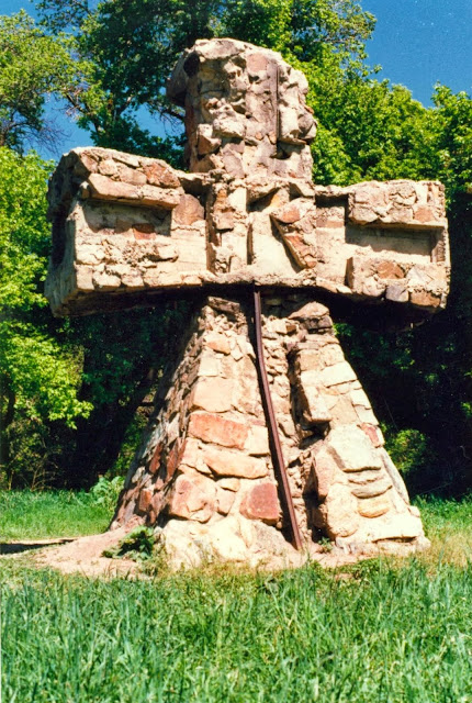 |
| Kay's Cross |
My friends and I spent all of our time playing in that hollow--tubing the creek and building secret hideouts, treehouses, and underground huts. Blazing trails and daring to crawl through dark, slimy culverts. Swimming and rafting in the irrigation ponds. Playing pirates and shark attack, Batman and dirt clod war. Building string telephones, making mudballs, skating on the ice--and falling through it more than once.
Exploring the Hollow from top to bottom, every way we knew how.
And yet, we had no idea that Kay's Cross even existed. It was a mystery so deep we didn't even
know it was a mystery.
Ten or fifteen years later when some of our Kaysville friends finally let us in on the secret of Kay's Cross (thanks, guys!), a few furtive visits to Kay's Cross brought to my mind the same questions that many have asked about Kay's Cross:
- Who built it?
- When did they build it?
- Why was it built?
- Was it built by polygamists? Or satan worshippers? A religious cult? Early pioneers? Native Americans? Early trappers? Or someone else?
- Why a cross? Mormons don't build crosses--they don't even like them. Fundamentalist Mormon polygamists--if they were involved in building it--shun the cross as a symbol even moreso then mainstream LDS.
- And why a cross with that particular and unusual flared shape?

- Why a "K"? Was Kaysville founder William Kay involved?
- Why the Ts and hollow squares in the ends of the arms?
- Was someone buried nearby? Or inside the cross?
- Was a murder involved? Or a tragic death?
- Why was the cross abandoned and unused for so many years?
- Why was the cross blown up in 1992, and who did it?
- With so much interest and so many visitors over so many years, why is so little known about Kay's Cross? Is it really a deep, mysterious, or somehow dangerous secret?
 |
| Holmes Creek Hollow in 1953. When we moved to the hollow in 1969, the
area still looked much the same. I've marked the location of our home
to the left and Kay's Cross to the right. Boynton Road snakes through
the center of the photo, almost connecting the two locations. The small
reservoir to the lower left and the large reservoir in the center where
the boundaries of my world for many years. (Click for full sized view.) |
Looking back at our time that mysterious hollow, I realized these were just the beginnings of the questions I had about our little neighborhood and the people who lived nearby.
- Who were our neighbors who owned the farm on Boynton Road where the cross is located? And what about our other neighbors? Some were new, like us, but some had lived there a l-o-n-g time.
- Who lived in our hollow before? Who were the first Mormon settlers to come there? Were there trappers or explorers before them? Were there Native American tribes before them? And if so, what happened to them?
- Who built the irrigation reservoirs--the upper and the lower--and why are they both dry now? What about the other reservoirs around town? Who owns them--what are they for?
- Boynton Road--who was "Boynton" and why was a road named after him?
- What about other local features obviously named for someone--Green Road, Raymond Road, Flint Street, Angel Street, Shephard Lane, Nichols Road, Parrish Lane, Kay's Creek, Holmes Creek, Baer Creek, Haight Creek, Hod's Hollow, Adam's Canyon, Gailey Park, Francis Peak, Thurston Peak, Hill Field, Kaysville, Layton--and many more. Who were these people?
- What about those other random and slightly mysterious things one sees around town? Why does Kaysville (of all places) have a grain elevator? What about those mysterious industrial works on the mountainside? And what about those giant golf balls on the top of Francis Peak?
- And how about those East Winds?
 |
| Pirate Treasure Hunt in the Hollow! This was my first birthday after moving into the Hollow. |
And some things are a little more mundane--things that only those of us with an interest in urban planning and development might notice. But still, there
just might be a good story behind them.
- Why does Kaysville's Main Street have such a strange zig-zag?
- Was there really a trolley stop in front of Kaysville Elementary?
- And what about the other unused rail lines that run through west Kaysville--when built, why abandoned?
- Why do the North Fork of Holmes Creek and the main fork never meet up? And why do so many of the local creeks--important enough to host mills and create hollows deep enough to deter all but the most determined road and subdivision building--seem to complete lack proper names on official government maps?
- Even a casual look at a satellite or topographical map will show any number of mysterious lines and traces going across the countryside and even through town. Where do they go--what are they for?
- Where was the old Kaysville Fort? Are any traces of it left?
- And what about old pioneer roads and trails--are they still used or can they be found?
- What was life like in the days when Kaysville was a small farming community? What was it like before it was filled by suburban neighborhoods--and what was it like before even that, and before that?
 |
| Holmes Creek Hollow in 2015 - same two locations marked as above: Our home to the left and Kay's Cross to the right. |
And I don't want to get all maudlin or overly philosophical here--but at a time when nearly every open space in Davis County has been filled in, paved over, connected, and industrialized, the Boynton Farm, surrounded by modernity on all sides, still seems frozen in the past. That last lonely strip of Boynton Road--once you leave the newly "improved" portion behind--is still a 10-foot-wide meander along ditches and over ruts, much as it must have been 150 years ago. It's a paved road only in the very loosest sense of the word "pavement".
 |
| Boynton Road and the Boynton Farm, 2013 |
And those who live and work there, in the fields and the orchards, are trying their best to maintain a way of life that existed on the Mormon frontier 150 years ago--and that most of us left behind 100 years ago. In many respects, the way they live on Boynton Road today could not be too far distant from the way Elijah and Mary Laycock, Thomas and Mary Ann Green, Rosel, Mary Ann, and Hannah Hyde, and other early Mormon settlers of the Holmes Creek Hollow area lived.
So--a little experiment investigating the neighborhood history of the Holmes Creek Hollow just might be profitable.
It might solve a few mysteries, uncover a few good stories, and tell us a little about those who came before us--and about ourselves.
And it just might settle, once and for all, the mystery of who built Kay's Cross--and why.
 |
| Mary Ann, Rosel, and Hannah Hyde. Mary Ann lived in town; Hannah--the second wife--lived on the Hyde farm toward the western end of the Holmes Creek Hollow area. |
I guarantee you--murders and tragedies abound. Mysterious, gruesome, ghastly, morbid, shocking, appalling, puzzling, secretive, mindblowing, bizarre, nonsensical, dire, dreadful, disastrous, and frightening. Criminal, lawless, and villainous. And to balance things out: Heroic, daring, adventurous, brave, courageous, intrepid, and patriotic. A whole lot of steadfast and determined.
We'll find all those qualities in Kaysville history--each and every one of them in spades.
And they are
all connected with Holmes Creek Hollow and the Boynton Road--somehow.
But are they connected with Kay's Cross itself?
Stay tuned--because we're going to find out.


